News
This Phenomenon Is Fueling Southern California's Devastating Fires

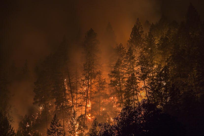
Multiple active wildfires are burning across Southern California, closing roads, forcing people to flee their homes, and taking dozens of lives. The main ingredient fueling the flames are the Santa Ana winds, but you may be wondering: What exactly are Santa Ana winds? The natural phenomenon is famous for creating devastating wildfires.
The National Weather Service defines Santa Ana winds as "a weather condition in which strong, hot, dust-bearing winds descend to the Pacific Coast around Los Angeles from inland desert regions." Because the winds are so common to the region, they were named after California's Santa Ana Canyon.
UCLA's Department of Atmospheric and Oceanic Sciences explains how dangerous the phenomenon can be. "Santa Anas can cause a great deal of damage," its website says. "The fast, hot winds cause vegetation to dry out, increasing the danger of wildfire. Once the fires start, the winds fan the flames and hasten their spread." Although it makes sense to assume the hot winds form because of the desert surroundings, the department's website dispels this myth, writing: "Actually, the Santa Anas develop when the desert is relatively cold, and are thus most common during the cool season stretching from October through March."

According to the Department of Atmospheric and Oceanic Sciences, the winds begin in the Great Basin, which spans sections of Wyoming, Idaho, Utah, Nevada, Oregon, California, and the Mexican state of Baja California. UCLA professor Robert Fovell explains on the website:
During the winter 'half-year,' the Great Basin tends to be cooler than the LA Basin. Periodically, high pressure builds over the Great Basin. In the Northern Hemisphere, air flows clockwise around high pressure systems. For highs located in the Great Basin, that clockwise flow pushes air into the LA Basin from the northeast and the east. Thus, the Santa Ana winds start in the Great Basin as a cool or even cold wind.
Because of Southern California's overall climate, the Santa Anas combine strong, hot winds with a dry landscape, which inevitably leads to wildfires. Fires are more likely in the fall since the region is coming off of a hot, dry summer. However, they can start fires any time.
A Southern California Geographic Coordination Center report notes that it's not uncommon for Santa Ana winds to last multiple days during the winter, as they have this week. December and January typically see the most windy days, with the gusts slowly fizzling out in February. The Dec. 5 report reads:
Santa Ana winds typically become stronger during this time of year with multiday events becoming more common through January. Fuels remain very dry and will support significant fire activity during periods of offshore windy conditions.
The fires currently engulfing Southern California are expected to continue the rest of the week as the winds get stronger before beginning to weaken on Friday. The Los Angeles Times' Sarah Parvini, Joseph Serna, and Alene Tchekmedyian reported Thursday morning that weather officials are expecting the winds to get even stronger through the day, with speeds reaching up to 70 mph — powerful enough to knock down trees and power lines, as well as spread fire even faster. Up in the mountains, they reported that winds could reach up to 80 mph.
A red-flag warning was issued across the region through Saturday. As Parvini, Serna, and Tchekmedyian explained:
The warning, which indicates extreme fire danger because of gusty winds and low humidity, will be in effect through Saturday in Los Angeles and Ventura counties, where fires have scorched more than 80,000 acres and destroyed many homes.
If you want to track the multiple wildfires, you can follow The Los Angeles Times' live updates as well as sign up to receive text alerts from the California Department of Forestry and Fire Protection.
