News
Winter Storm Jonas Is Even Scary From Space
All throughout the American southeast, and now the Mid-Atlantic and northeast too, people are preparing for a hellacious winter storm. The Weather Channel named this snowstorm "Jonas," although you can decide what precisely you want to call it. In any case, it's a big deal, with record-rivaling snowfall expected in Washington, D.C. and hazardous storm conditions anticipated along the eastern seaboard. And if you're curious to see precisely how this thing gathered steam, the folks at NASA have you covered ― here are five GIFs of Winter Storm Jonas from space.
There's just something about satellite imagery, right? Sure, it's one thing to read about a climactic storm, and it's another thing to watch video of some intrepid reporter weathering those conditions. But it's something altogether different to take a moment and observe what the storm's trajectory across the United States actually looks like from above, with a far wider perspective on the planet's surface.
And that's precisely the view that NASA's provided everyone with, when they uploaded video from the GOES-East satellite showing the storm's trajectory from Tuesday through Thursday. The relative tranquil of the pictures betrays just how insignificant these kinds of things look from a great enough distance, even while they're wreaking havoc here on the Earth's surface. Here's the video, broken into five easily digestible GIFs:
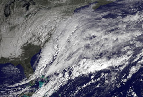
1. Jan. 19, Morning-To-Afternoon
This is what the stormy skies looked like from above on Tuesday, between about 6:30 a.m. and 1:30 p.m. ET.
2. Jan. 19 to Jan. 20, Afternoon-To-Night
This one takes you from about 3:30 p.m. to 12:30 a.m. ET ― in fact, you can see the shroud of nighttime darkness sliding over the east coast.
3. Jan. 20, Morning
Now, here's from about 12:30 a.m. early Wednesday morning to about 9:30 a.m. ET. Again, you can see the sunlight stretch across the Atlantic and the American east, illuminating the swirling storm clouds.
4. Jan. 20, Morning-To-Evening
Now we're going all the way from the morning well into the evening ― the above shows Winter Storm Jonas from about 9:30 a.m. to about 6:30 p.m. ET.
5. Jan. 20 to Jan. 21, Evening-To-Morning
And finally, here's the latest footage the NASA satellite captured ― this is from about 6:45 p.m. on Wednesday evening, to about 5:30 a.m. ET on Thursday morning. WInter Storm Jonas will be ongoing through the weekend, and is expected to head out over the Atlantic after Sunday.
Images: NASA (5)
